Hi.
Welcome to my blog/travel guide. Take a look around, you never know what you might find!

Welcome to my blog/travel guide. Take a look around, you never know what you might find!


Joshua Tree National Park
Mojave National Preserve
Mojave Lava Tube
Kelso Dunes
Red Rock Canyon State Park (CA)
Trona Pinnacles
Death Valley
Ubehebe Crater
Racetrack Playa
Badwater Basin
Golden Canyon
Zabriskie Point
Valley of Fire State Park (NV)
Red Rock Natural Conservation Area
Hoover Dam
Oatman, Arizona

Our adventure began with a bit a drive (240 miles) to Joshua Tree National Park from Phoenix. The drive felt long, since this stretch of I-10 is rather uninteresting, especially for Southwest standards. The weather was dreary and a sign of what was ahead of us. An unusual weather pattern over southern California kept us from seeing the sun until halfway through the second-from-last day of this trip. The terrain begins to get interesting ~50 miles East of the road into Joshua Tree, right about where the actual park boundaries extend to. We stopped at the Joshua Tree National Park sign to take pictures, as you do, and met a Spanish family. One of the two adorable young daughters, probably six years old, could not contain herself staring at Donnie. Nearly shaking with excitement she scooped him up like a goat before Becca could finished saying “You can pick him up”. Elated, she stood their holding him like it was her life’s greatest accomplishment, smiling ear to ear. We took their picture in front of the sign, and they took ours. We have a tradition of posing Donnie in front of every new national park or state welcome sign we encounter. We set him of the concrete footing for the sign and took his picture, as usual, and the little girls thought it was the greatest thing in the world: a tiny Chihuahua model, posing for his picture. “Beauty-full!” they exclaimed. “Beauty-full” and they skipped back across the road to their car, laughing.
Continuing on, into the park, we stopped at the Cottonwood Visitor and got our first taste of the mob of people that plagues Joshua Tree [JT]. The visitors center is small and has a shelf or two of mementos for sale. First stop on our journey through the park was the Cholla Garden, an enormous swath of cholla cacti of all shapes and sizes. Possibly the coolest part is seeing the dead ornate cholla ‘skeletons’ lying around amongst the healthy ones. I never imagined a dead cactus to look so beautiful. Next we decided to drive straight out to the Oasis Visitors Center and see the Oasis of Mara. This may have been more impressive if it were in the middle of a vast desert like it once was, but just behind you is suburbia and a decently busy road. Middle class ranch houses, chain-link fences, and telephone poles just kind of kill the mood here. The oasis visitors center is essentially the same as Cottonwood, but with a few more items for sale. The next morning we stopped in at the primary visitors center at the north-east end of Park Blvd expecting that to be the good one, since the other two were fairly small, but to no avail. It turns out that JT, despite its popularity, still hasn’t quite evolved the infrastructure of a National Park since its promotion from National Monument in 1994.
From the Oasis, we hit Skull Rock, where I got to test out my patience. I will never understand people that insist on taking their pictures with every single tourist attraction. Here and there I understand, but other people would like a picture of the feature without you and your mom posing in front of it. A seemingly infinite line of people wanting their picture with Skull Rock made it a challenge to get a picture of just Skull Rock.

A Cholla “skeleton”
We began with a quick drive through Twenty Nine Palms, a pretty neat little city, before heading north toward Amboy. N. Amboy Rd takes you through Mojave Trails National Monument, and the vistas overlooking the salt flats are spectacular. Coming down from the hills you pass by salt farms and through a black volcanic field left by the volcano that produced nearby Amboy Crater. We’ve seen our fair share of cinder cones so we felt the view from the road was sufficient. N. Amboy Rd ends at National Trails Highway, also known at Route 66. We stopped at Roy’s to get a picture of the iconic sign and take a look at the old motel. It is such a shame that you can no longer book a room here. I would have very much loved to do so. Continuing east, a detour sends you North along Kelbaker Rd. toward I-40. Luckily this is where we were headed anyway. Continuing past the interstate, Kelbaker Rd. takes you through the heart of the Mojave National Preserve, a beautiful desert wilderness with cacti and mountains. Roughly fifteen miles from I-40, a dirt road heading East takes you to Kelso Dunes. This enormous dune field covers 45 sq. mi (the largest in the Mojave Desert) and some dunes here are as tall as 650ft. Donnie loves nothing more than kicking up sand in a sweet, fast and fur-ious style burnout, so this was his favorite part of the trip. From here, it’s only 32 miles to the Mojave Desert Lava Tube. Despite the fact there are no signs for the tube, it doesn’t seem very well known, and it’s quite remote, there is still a nice metal staircase that leads down into the tube. Bring a flashlight (a real flashlight, not your phone) because the opening lets in enough light to make it nearly impossible for your eyes to get dark-adapted. We almost didn’t see the small passage into the second chamber of the tube (the better part). Here, an opening to the surface lets a beam of light shine in through the ceiling and if you’re a real photographer I imagine you can get some seriously cool shots in this chamber. You’ll have to crouch quite a bit, or maybe even crawl to get through the passage, depending on your height. The surrounding landscape is covered in basalt and huge red and black cinder cones dot the horizon. It’s a great drive. Continuing north-east along Kelbaker Rd. we eventually left the Mojave National Preserve and were immediately punched in the face with civilization once again. An enormously bright red light shines in the distance, easily visible for miles. “Maybe it’s a casino, or a truck stop, or an obnoxious billboard.” We pondered. We could not figure it out until we were directly in front of it… It is the world’s largest thermometer, in Baker, California. That day was about 50degrees and this part of the country regularly sees temperatures over 100, so the thermometer was only partially lit. I can’t imagine how bright this beacon is when the temperature soar. It must be especially blinding for nighttime travelers along I-15 (which Baker lies along). Baker is also home to Alien Fresh Jerky, an incredible oddity that sells a seemingly infinite variety of beef jerky, including invisible jerky! The building looks like a combination of a medieval castle and space army tank. In the parking lot out back a UFO shaped building serves soft pretzels, and they are currently constructing an alien hotel. This store also has an incredible assortment of craft hot sauces as well as sodas. You can find anything from your typical soda flavors like cherry to chocolate, butterscotch, or Diet Dang. From Baker, we took I-15 south-west toward Barstow, then exited onto Calico Rd to get to Calico Ghost Town, an abandoned silver mining town at the foot of the mountains that has been preserved and turned into an historical amusement park. We ended the day in Barstow, which is also the terminus of I-40. The interstate travels more than 2500 miles from the coastal city of Wilmington, North Carolina, just to end 100 miles from the Pacific Ocean in Barstow, CA.

Roy’s on Route 66 in Amboy California

Kelso Dunes, Mojave National Preserve

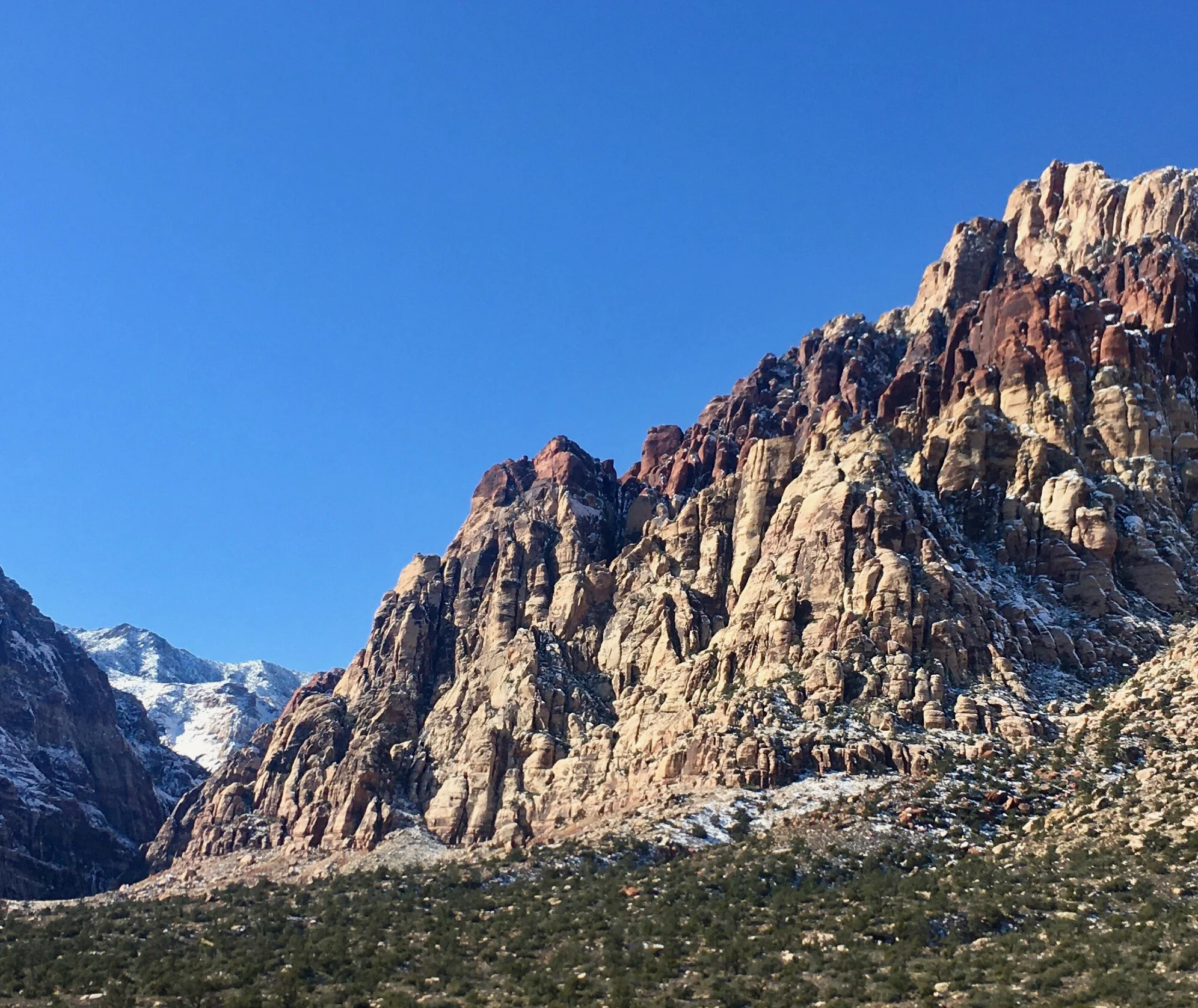
Red Rock Canyon State Park, California
That morning, we left Barstow around 7:00 am to adhere to a rigorous schedule. This area of California has so many tiny treasures to be seen, but individually they aren’t necessarily worth a trip back to the area, so it was important for us to hit as many as we could, in case we never came back, however unlikely that is. Our first destination was Red Rock Canyon State Park, a beautiful collection of eroded red cliffs that somehow dodged my radar until the week before we left for this trip. Our morning drive began under a light layer of fog that got progressively thicker and thicker as we headed West. I have no idea what this stretch of California along CA-58 looks like because I couldn’t see more than thirty feet in front me for more than an hour. The fog briefly cleared as we were passing the Hyundai-Kia Proving Grounds, more than sixty miles from Barstow. Curiously, the Honda Proving Center is only ~15miles North of the Hyundai facility on the other side of California City. Pilots flying over the grounds report cars taking shelter immediately once in sight.
With Hollywood-production perfect timing, we punched through the fog to see the Alta Wind Energy Center sitting at the base of the towering Tehachapi Mountains. Alta is the largest on-shore wind farm in the U.S. and the third largest in the world, producing 1500MW (3/4 that of the Hoover Dam). Minutes later the fog was back, just in time for us to drive right past our destination. To turn around, we turned down the first road-looking path, which coincidentally lead us to the visitor’s center. Not surprisingly, it was closed (on Christmas Eve), but a map on the wall outside helped us find our bearings. Luckily, by the time we regrouped the fog had burned off a bit and we could get a clear view of the cliffs, which are incredible. We then took the Iron Canyon 4WD drive around the park and stumbled upon some spectacularly secluded sights. 4WD is a must here, and high clearance is strongly recommended. The dirt road is rough, gouged, and quite steep in spots. You will pass through a few washes, so this road may become impassible during/after a rain. If your vehicle is capable this is a lot of fun to drive. A Toyota Tacoma SR5 worked great. Despite being only 1hr from Bakersfield and 2hrs from Los Angeles, we didn’t see another person here.
Back in the car, we headed toward Ridgecrest, just outside of China Lake Naval Air Weapons Station, a weapons research facility that is larger than Rhode Island and represents 85% of the total land owned by the U.S. Navy. Twenty miles East of Ridgecrest is the Searles Valley, where millions of tons of borax, soda ash, salt, and other minerals are extracted from a dry ancient lakebed. This is also where we found the Trona Pinnacles, a series of otherworldly rock spires, some as tall as 140ft. These pinnacles formed on the lakebed when calcium rich springs interacted with minerals in the lake from as long ago as 100,000yrs to as recent as 11,000 years ago. Similar processes are still occurring today in Mono Lake, an incredibly alkaline (the opposite of acidic) lake ~200 miles north near Yosemite Valley. These rocks are so foreign looking they are used as backdrops in countless movies including Star Trek V and Planet of the Apes (2001). Just West of the pinnacles, along CA-178, are the hilarious Fish Rocks, a group of split boulders that someone painted fish mouths onto. I couldn’t resist putting Donnie in one of their mouths. From here, it would have made the most sense to head north-west towards Death Valley (our final destination for the day) but this route would have bypassed the scenic western entrance into Death Valley through the Panamint Mountains. I also wanted to try to get a look at Mt. Whitney, the tallest mountain in the contiguous United States (14,505ft.), but the incessant unrelenting fog denied me the chance.

The scenic drive into Death Valley was incredible, especially since we weren’t expecting to see snow. The road gradually ascends to Father Crowley Point, which offers enormous views of Panamint Valley, but for us the mountains across the basin were shrouded in fog. The descent into the valley takes you around cliff hugging curves, with the sun dipping behind mountain peaks, reminiscent of a sports car commercial. We passed Stovepipe Wells and the Mesquite Flats Sand Dunes just as the day’s last rays of light said goodnight. An ominous and foreboding darkness quickly set in. At night, the only sources of light in the valley are other cars’ headlights, and with the cloud cover we had been dealing with all day, it felt almost apocalyptic. This wasn’t your every day darkness, it was advanced darkness.

Father Crowley Point
We set up camp in the dark, but when staking down the 10x10 canopy that accompanies our tent, we realized that somehow we had forgotten the stakes. Luckily, Furnace Creek has a number of amenities, and the store is open late. We were able to find stakes and firewood and headed back to camp. Campfire-cooked sausages washed down with a cold Sasperilla hit the spot and we settled in for the night, waiting for the cold. We don’t camp in adverse conditions often and we don’t have many cold weather camping supplies, so we were a bit nervous when we saw the temperature would drop down to 38 that night. Usually we sleep together in a two-person sleeping bag, but we came prepared with two individual bags, both rated for below 30. We also brought an air mattress with us. Not one that you blow up manually, but a swanky one that’s nearly the size of an actual queen size bed, frame and all. We weren’t completely sure if it would fit in the tent, so we brought our usual sleeping pads with us. Before the trip, we purchased a DC converter, so we could simply plug the self-inflating air mattress into the truck. We inflated the mattress next to the car in the parking area, carried it over to the tent, and shoved it in. I’m glad we did this in the dark, because it was ridiculous. The mattress spanned nearly the entire tent, but it was fantastic. The night was cold, but not having to worry about a narrow sleeping pad beneath us helped make it quite bearable. Donnie, on the other hand, could not figure out how to get comfortable in the tiny flexible Sarcophagi. He tossed, and turned, and chose the most inopportune places (like between my shoulder blades) to try to get comfortable. I kept worrying that I might crush or suffocate him in my sleep. Next time he’s getting his own sleeping bag. Are there tiny sleeping bag models at Dick’s?

Snow on Titus Canyon Rd.
Tea Kettle Junction
Today was all about driving. Just after 9:00am we took a stroll out the north-eastern entrance of the park to check out Rhyolite, Nevada, a remarkably modern ghost town. Concrete facades, sidewalks, and basements were a surprise to see in an abandoned town. The town came and went in a flash around 1900. Rhyolite had running water and electricity, a school, a hospital, and even an opera house. It was unusual to see the ruins of buildings that were younger than many of the buildings I’ve been in in Buffalo. From Rhyolite, we headed back the way we came, but before entering back into Death Valley, Titus Canyon Rd splits to the right. The dirt road was covered in a few inches of snow, which made the pass through the mountains just a little more treacherous than we’re used to. We slipped and slid a bit, but the Tacoma held firm. Coming down from the mountains, walls of rock closed in around us. Gaping canyons became tighter and deeper until we passed through the Dolomite Narrows, nearly shear rock walls encasing a winding dirt road just wide enough for a vehicle.
Titus Canyon Rd ends at Scotty’s Castle Rd, which runs up the northern leg of Death Valley. It had been lightly drizzling most of the time we were in the valley, so normally-dry washes were actually running with water. The sediment is so loose here that even the slightest amount of rain causes roads to be inundated with debris. A few spots had speed bumps of rock and sand over a foot thick. The final stretch of the road to Scotty’s Castle, a 20thcentury millionaire’s mansion, was washed away in a flash flood in 2015 and has not been re-opened. The park expects to have the road repaired sometime this year. Before the road closure, Ubehebe Rd forks left, up the side of a massive volcanic crater. Ubehebe Crater is a half of a mile wide and was caused by a steam explosion from superheated ground water. Nearly touching the rim of Ubehebe is Little Hebe, a smaller crater of similar origin. Here you can walk the rim of Ubehebe, hike down the steep walls to the center of the crater, or take a short but steep walk to the rim of Little Hebe. The orange layers of rock underlying the stark black basalt that covers the area is exceptionally unusual. Not feeling particularly intrigued by the idea of hiking, or sliding, to the bottom of the crater, we took off toward Racetrack Playa. The dry lakebed is 27 miles down a dirt road toward the desolate and isolated part of this desolate and isolated national park. Most travel guides mention that this is a dirt road, but fail to emphasize four miles of driving up a wash, which happened to be flowing fairly well. The dirt road is more of a rock road, and the NPS recommend having off road tires, since the rocks are sharp. The drive is 54 miles, pavement to pavement and 150 miles gas station to gas station. We had half a tank of gas in a rental car with the “maintenance required” warning light on… on Christmas. These are the kinds of conditions that would make me shake my head and ask the eleven o’clock news “what did they think was going to happen?”, but were not about to turn around. The road was tough but we saw a Chevy Aveo coming back from the direction of the Playa, so that gave me some confidence. “New York” I could see behind their West Herr license plate frame, from a car dealer in our hometown. What are the odds?
After nearly an hour of jostling we arrived at Tea Kettle Junction, a three-way intersection with a wooden sign in the middle, where travelers hang tea kettles. I wonder if park rangers clear them every so often or if it’s like take a penny leave a penny. For the last few miles the road gets just a bit bumpier and the playa comes into sight. At opposite ends of the lakebed, two miles apart, the difference in elevation is only 3 inches. It’s like a blank slate of Earth. It’s aggressively flat. When there’s even the slightest precipitation, the dry, cracked playa becomes incredibly slick, and rocks that have tumbled down from the mountains get pushed around the valley floor by the strong prevailing winds, like a giant air hockey table. The rocks leave behind tracks, making them appear to be alive and on the move. The sight is so peculiar it almost makes you think they’ll all move a few inches once you look away, but stop dead once you look back. I had originally planned to spend sunset at the Playa, but figured that driving that road back in the dark was the icing on the cake of recklessness. We returned to pavement with just enough sunlight to actually see it and just enough adrenaline to forget about the speed bumps of stones that lie ahead. Luckily the first one we came upon wasn’t bad, so hitting it at 45mph wasn’t a problem. The heavy blanket of black makes your headlights appear to be fighting the darkness, and losing. The intervals between silt mounds was just long enough for me to get complacent and had to nearly slam on the breaks each time, and there were a bunch of them. We made it back to Furnace Creek and as our headlights rolled over our campsite we noticed four white posts in the air. Despite going to the store to buy some emergency tent stakes, we forgot to put them in, and the wind flipped the canopy over, onto our tent, like a the burrito wrapping ringer they bring in when the rookie rips your tortilla at Chipotle. Luckily our neighbor said it only happened an hour previous, so we didn’t feel completely mortified. It was easy to flip back, so we quickly got to sausages and sleeping. The sky was just a bit hazy and, being a Dark Sky park, I could see the winter Milky Way and a tiny shooting star. I figured that was the perfect punctuation on the paragraph of the day and hit the sack. Donnie figured it out a bit, but still not great.

Racetrack Playa
We awoke early so we could pack up the campsite. Everything went back into the truck with ease and we were quickly on the road. First stop before heading to southern Death Valley was gas. Prices at Furnace Creek started at $4.43/gallon, which was nearly double what we pay in Albuquerque. Adjacent to the gas station is the mechanics shop, where we noticed a black Chevy Aveo, on the back of a flat bed tow truck, with license plates from New York. Our first sight for the day was the Twenty Mule Team Borax wagon train, left in the desert for 100 years. These massive wagons used to haul borax from the refinery near Furnace Creek to a rail station more than 150 miles away. The amount of effort that went into acquiring a mineral that most people haven’t even heard of, let alone know what it’s used for, is incredible especially considering the technologies used at the turn of the 20th century and the extreme heat in Death Valley. It’s hard to imagine money being made off of this endeavor, but the business was quite lucrative. Our next stop was the rather unimpressive Badwater Basin. It’s sacrilegious to come to Death Valley and not walk out to the lowest point North America though, so we did. Slowly checking off all of the sights in the valley, we stopped by Devil’s Golf Course and had to remind someone that flying drones in a national park is illegal. Artist’s Palette is unreal. It’s hard to believe the colors in the sediments here are not from humans. Battery acid greens, deep purples, golden yellows, and rusting reds really look like a geological artist’s palette.

Artist’s Palette
Next on the list was Golden Canyon, the supposed filming location for a part of the original Star Wars: A New Hope. I was slightly skeptical, because over the summer I had been lead to believe that the canyon used for filming R2D2’s journey to find Obi Wan, before being captured by Jawas, was Plaza Blanca in New Mexico. It was glaringly obvious after hiking through Plaza Blanca that this was not the correct place, however beautiful and otherwordly the canyon is in its own right. Taking a hike through Golden Canyon was a different story though. As an avid fan of the original trilogy I could just sense that this was the right place. A crevice in the soft walls is where a Jawa spied on R2 from. A boulder leaning against the wall has slid a little since the 70s, but two sets of Jawa eyes once appeared through the shadows here. It was obvious. This was the place. We hiked a bit until we could see the Cathedral wall and Manly Beacon and headed back after exploring some small branches of the canyon. It’s possible to hike straight through to Zabriskie Point, but that’s where we were headed next, so it didn’t seem necessary. The view from Zabriskie is bewildering. Rich golden eroded badlands fade into chocolaty browns permeated with tans and oranges. This is a Goron’s paradise. Twenty Mule Team Canyon was next, which is a scenic one-way dirt road through unearthly colored sediments. The road is well maintained, albeit steep at times, but after the previous day’s adventures this drive felt like the kiddie roller coaster. It is beautiful though. Our very last stop in Death Valley was to be Dante’s View (also used as a film location in Star Wars), but the road up to the outlook was closed, so that was that. We began our drive back to civilization with a bit of the post-performance blues, but tomorrow we would be visiting another spot that’s been high on my list for years, so we had that to look forward to. Our first taste of society was in Pahrump where we stopped for a snack at a gas station. It blew my mind that people were playing slots in a rather run-down gas station in the middle of the afternoon. Welcome to Nevada. We got to Las Vegas right as the sun was setting and, since I’ve never been, we took a stroll down the strip. I was actually quite impressed and did not hate the city like I assumed I would. We had some time to kill, so we looked into seeing a show, but everything that sounded interesting was a bit out of our price range. Taking a hot shower in a nice motel room was enough for me though. We checked out the lights above Fremont Street and sat down for a bite to eat at a tapas restaurant before calling it a night.

Zabriskie Point
This park has been on my list since before we moved out west. I’m a sucker for scenic drives and sandstone formations and this park is loaded with both. Valley of Fire has the feel and bravado of a national park, but is already overcrowded as a measly state park. These delicate features would probably suffer dramatically if this were to gain the notereity it actually deserves.
The park is less than an hour’s drive from Las Vegas. The rest of the landscape in this area of Nevada is relatively mundane for a western state, but vibrant red sandstone jumps out as you round a corner on Valley of Fire highway. Everything in the park is named “fire ____”. Fire Canyon, Fire Cave, Fire Wave, etc. There is no shortage of interesting rock shapes resembling a variety of things including Piano Rock and Elephant Rock. On the White Domes Trail you can walk through a short slot canyon and a small rock arch. The Fire Wave Trail takes you up close to one of the most beautiful sandstone sculptures in the world.
It’s not often I set aside an entire day for one location. National Parks are the usual exception, so the fact that we had nothing else scheduled for the day is a testament to how excited we were for this park. I had originally intended on splitting the day between Valley of Fire and nearby Gold Butte National Monument but it is almost entirely undeveloped and since we were in a rental truck we decided we’d save it for another day. Giving ourselves all day in the park was great since we were able to leisurely see all the sights, and do both the Fire Wave trail and the White Domes trail. I highly recommend each hike. They are both fun and easy hikes to great sights. The most challenging part of each hike was finding a parking spot. We took the long way back to Vegas through Moapa Valley, and since the night was still young we hailed an Uber to take us to the strip. We didn’t have grandiose plans, but I wanted to see all the places I’ve heard so much about. We took a peak at Caesar’s Palace, the Bellagio, and had an unorthodox Mexican/Chinese fusion dinner at the Cosmopolitan.

The Wave, Valley of Fire State Park, Nevada
On every trip we take, at the end of every chapter, the final day is unmistakably bitter sweet. It’s a terrible disappointment that it’s over, yet we just want to get home to relax. I find it very useful to allow yourself an extra day at home after a vacation to properly relax and unwind. Heading back to real life the morning after returning from a trip is a great way to find yourself needing another vacation after a week of being back. The final day on the road wasn’t designed to be spectacular, but I was finally going to check off an item on my list that has been tapping on my shoulder for years.
Every mile of highway felt like the final montage in a corny movie where the unconfident underdog actually makes it into Harvard or onto the big sports team. Some 90s rock song we all totally forgot about plays while the camera pans in from a helicopter to a perfectly-restored vintage car gently going mach 3 down the interstate. Slowly the details of the car come into focus, the kids head resting on the open window sill, with long hair flapping in the wind, before the camera pans the horizon as the sun sets behind the mountains…except that I’m completely bald, the song is by the Spice Girls, and I’m on my way to see some donkeys in a kitchy abandoned mine town.
Walking across the dam wasn’t as awe inspiring as I had always imagined. The dam is impressive, don’t get me wrong, but most people imagine a straight plummet down the face of the dam to the canyon below, and it actually curves a bit like a toilet bowl. This curvature makes it difficult to see down to the base. The better view of the dam was from the bridge sidewalk.

Burros in Oatman, Arizona
Red Rock National Canyon National Conservation Area, Nevada
My grandfather is one of the nicest people on the planet, yet will subtly threaten to beat you up in the backyard nearly every time you meet. My grandparents and aunt drove the entirety of Rt. 66 from Illinois to California one year, and when my grandfather discovered our plans to move to the Southwest he only had one recommendation for us. Oatman, Arizona. You can ask him why, but it’s really not clear to anyone, even him, what makes Oatman special. Feeding wild donkeys from the comfort of an air-conditioned vehicle and an old tavern that “has more flies than patrons” carry a certain je ne se qua for octogenarians I suppose. Sitgreaves Pass between Kingman and Oatman is a beautiful winding scenic drive along old Rt. 66 and the Ocotillo growing along the side of the road here put the ones in Joshua Tree NP to shame. The donkeys were fun and the town was every bit as kitchy as you might assume. Oatman is a wild-west shootout away from being the complete tourist trap package. Be careful with dogs around the donkeys, they are known to try to stomp them to death like they do with rodents. The sun began to set and we somberly sulked back to Phoenix, and real life. What a journey, though.