Death Valley National Park
Not many names conjure up such emotion like Death Valley does, although the valley has quite a vibrant history. Only a two hour drive from Las Vegas, this is one of the more accessible National Parks, but is only the 19th most visited. Encompassing more than 5000 square miles, the park is larger than Connecticut and is the largest U.S. National Park outside of Alaska.
The valley is enormous! It may just be the largest valley that a human can comprehend. There are larger valleys, but if both sides of the valley are not within sight, it’s difficult to get an accurate feel for how large it is. It’s incredible to look down the valley and see nothing. There are no buildings or trees and the terrain is relatively flat, so looking down the valley feels like you can see for millions of miles. Since the valley is so large, expect to do a lot of driving if you want to see all of the sights.
POINTS OF INTEREST
FURNACE CREEK
This is home to one of the only campsites that take reservations. The site has flushing toilets and communal dish sinks for campers. The starry skies of death valley are incredible, although it is unfortunate that the milky way is best seen during the summer and furnace creek was where the hottest air temperature on Earth (134deg F) was recorded in 1913. Furnace Creek has amenities including a gas station, motel/hotel rooms, general store, an auto shop, visitor center, golf course, museums, and restaurants. As with any remote amenities, prices are steep. The concessions at Death Valley are run by the same company that operate in Yellowstone and the Grand Canyon and if the food is similar, I do not recommend spending your money there. The gift shop is great though.
RACETRACK PLAYA
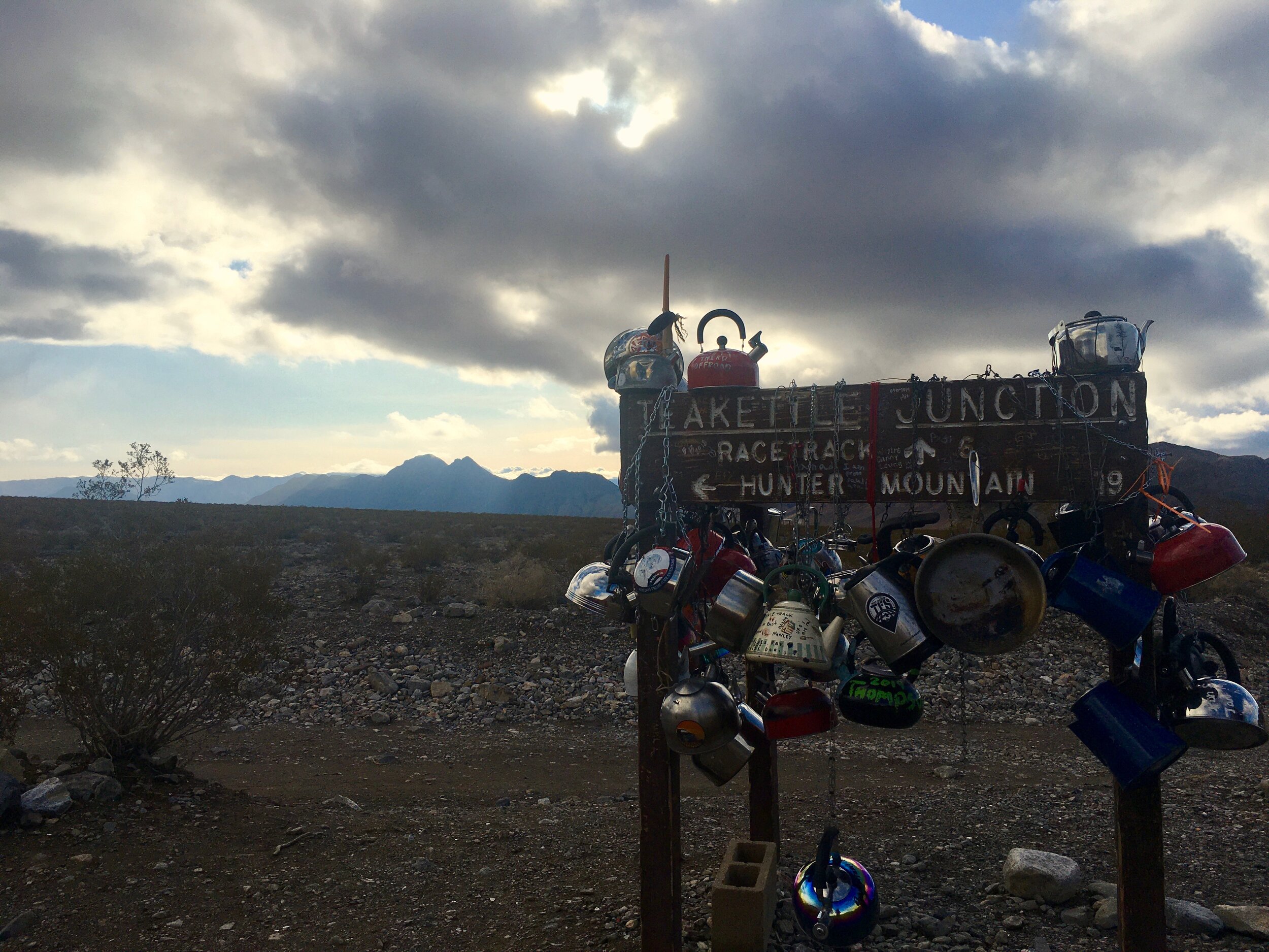
This is a surprisingly well-known part of the park considering how challenging it is to get to. From pavement to playa, it is a 27mile drive on rough dirt roads, covered in jagged rocks, marred with potholes, and littered with substantial puddles. High clearance is a must, and 4WD is recommended. It is nearly 150miles round trip from the nearest gas station, so fill up on gas before attempting this. From Ubehebe Crater you will drive 4 miles up a wash which eventually splits onto a rough dirt road with jagged rocks. Do not attempt this drive with compromised tires. The road is not an easy drive. Expect a pace of 20-30mph. About two thirds of the way to Racetrack Playa you will arrive at Teakettle Junction, a sign that people hang tea kettles from. Keep straight, and the road becomes slightly rougher, but not substantially. If you do not have a high clearance or 4WD vehicle, jeeps are available to rent at Furnace Creek.
Racetrack Playa Sailing Stones
The playa is incredible by itself, even without the sailing stones. The soil is the iconic, dry cracked dirt you imagine in a severe desert and the dry lakebed continues on for miles. Interestingly, the south end of the playa is only two inches lower in elevation than the north end, making it remarkably flat for as far as the eye can see. The soil becomes incredibly slick when wet and the high winds can push rocks across the flat surface of the playa, leaving trails in the mud, giving the impression that these rocks are alive and on the move. It is a sight to see.
ZABRISKIE POINT
This is a beautiful 360 view from a point up a short hill from the parking lot. The path is paved, so wheelchairs can make the climb, but the path is quite steep. Yellow colored badlands to the left give way to tan and orange striations with veins of chocolaty-brown.
HARMONY BORAX WORKS
This short walk takes you on a reading tour through the old decaying borax refinery. One of the wagon trains that the famous 20 mule team borax company used is still sitting on site.
TITUS CANYON DRIVE
Near the north-eastern entrance of the park you can find this one way dirt road that takes you into death valley, the scenic way. The road is winding, and dangerous, with precipitous cliffs, steep rocky roads with no guardrails, but if you have 4WD and a bug for adventure I highly recommend the ~2hr detour. At first you are taken through the mountains, up and down switchbacks, but then titus canyon closes in around you and shear rock walls flank you as snake your way into death valley through the dolomite/limestone narrows.
UBEHEBE CRATER
This half-mile wide crater is a beautiful display of the volcanism in Death Valley. The crater is the result of explosion of superheated gasses under ground 2-3 thousand years ago. The red-orange soil underlying the black basalt is a stark contrast and if it has recently rained, a pool of orange water will form at the bottom of the crater. You can walk around the rim of the crater, or up to Little Hebe crater not far from the parking lot. You can also walk down into the crater, but the walls are steep and the walk back up can be a challenge. It is roughly 500ft over 1/4mile.
Ubehebe Crater
DEVIL’S GOLF COURSE
Not far from Badwater Basin, a vast salt pan is all that remains of the ~30ft deep lake that used to exist here. When the lake dried up it left behind all the the minerals that have washed down from the mountains over the ages. The salt and gravel beds extend to over 1000ft. deep and some speculate as far as 9000ft. The salt crust heaves and cracks as it expands and contracts with variations in moisture and temperature. The jagged landscape gets its name from a 1930s National Park guidebook that stated “only the devil could play golf” here. If you’re disappointed that this isn’t an actual golf course, don’t worry there is am 18 hole, par 70, course at Furnace Creek just fourteen miles north. To get here turn down Salt Pool Rd off of Badwater Rd., just south of Artist’s Drive. Salt Pool Rd is a dirt road, but is smooth and manageable by just about any vehicle.
GOLDEN CANYON
This is the canyon where part of the original Star Wars (A New Hope) was filmed. The easy hike through this canyon is as strenuous as you make it. It is relatively flat after a few small step-size hurdles near the trailhead. You can explore the various branches of this winding shallow canyon with golden yellow walls. Nearly every variety of rock can be found scattered on the floor of the canyon and beautiful rock hunting is part of the fun of this beautiful walk. You can hike this canyon all the way to Zabriskie Point, or take the Gower Gulch loop (4.4 miles).
BADWATER BASIN
The lowest elevation in North America (282ft below sea level) sits only miles from Telescope Point across the valley (over 11,000ft tall). A natural spring feeds a pool of water near the road that is very saline. When a traveler’s mule would not drink from the pool he deemed it bad water, and the name stuck. There isn’t much to actually see here, besides the famous sign indicating the elevation. You can walk a mile so out onto the treaded salt flat to get to the real lowest point (the sign near the road is actually not the lowest)
FATHER CROWLEY POINT
If you enter Death Valley from the far west, you will take the scenic drive along rt. 190 through the Panamint Mountains. Father Crowley Point overlooks the Panamint Valley west of Death Valley. The view is incredible and is the second most expansive panorama you will see in the park, behind Dante’s View.
NATURAL BRIDGE TRAIL
Spanning an incised gully is a natural bridge carved by erosion. This is one of the easier hikes available in Death Valley. The one mile round trip can be done in under an hour. Thirteen miles south of Furnace Creek turn onto Natural Bridge Road. The short drive to the parking area is dirt, but well maintained.
ARTIST’S PALETTE
This fun, 9 mile one way loop, scenic drive is a must do. The drive is beautiful and Artist’s Palette is incredible. Colors range from battery acid green, to purple, to yellow, to deep brown. It really does resemble an artist’s palette. Vehicles over 25ft. long are not permitted on Artist’s Palette drive.


